Methods
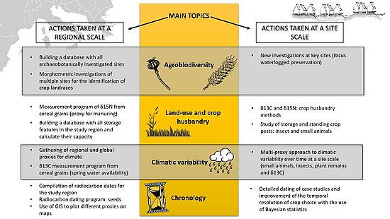
The project integrates several disciplines and multiple scales of analysis. Archaeobotanical analyses form the basis of the interpretation and construction of the discourse, since they inform us about what was grown and where. We will implement digital image analysis to go beyond the limitations of macroscopic identification of seed and fruit remains and use geometric morphometrics to identify crop types.
Single seeds will individually be radiocarbon dated (ca. 400 measurements) to identify crop changes over time in each region. AgriChange also uses carbon and nitrogen stable isotopes from cereal grains –preferably from dated contexts- to infer land-use changes over time (extensive vs. intensive farming methods). Carbon stable isotopes are also a valuable on-site proxy for crop water availability in spring and therefore might reveal short-term climatic changes, otherwise difficult to detect.
Additional proxies (storage features, insect and small animal remains) are investigated to reconstruct and understand food security in the past, including crop storage practices, storage capacity and crop pests. Recording changes in storage capacity and identification of crop pests in the study area will bring important insights into food security and risk management in the past. Climatic variability is considered at a large spatial scale using global proxies, as well as local to regional scale by compiling several climate proxies such as plant macroremains, insect and small-animal remains and δ13C records from cereal remains.
We will provide more details on methodological developments of the project in the near future.